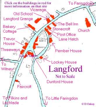
|
|
Written in about 1960 by the parish council
Walking
from the Church towards the village, it will be noticed that there is an
uneven field adjacent to the Church before the Bell Inn is reached.
Many
years ago a large house is thought to have existed, together with some
cottages, in this field. There are signs of sunken foundations under the
grass • At the back of the field there is still a ditch, which may
have been a simple moat, or even the remains of an earlier Saxon ditch.
From the
earliest time the village has been the property of the Church, and some
of the houses are still owned by the Church Commissioners. For this
reason there was never a Manor House of the type that still remains in
many country villages. The details given here have been provided by the occupants
of the houses described and thanks are due to all who took the time and
sometimes considerable trouble to dig Into title deeds etc. to provide
the information.
This Inn was originally built by the Ecclesiastical
Commissioners as two farm workers’ cottages. These cottages were the
two furthest from the road that now make up the Bell Inn and were built
about 1650 A.D. The part of the building, which is now the kitchen, was
used at some time as a Blacksmith’s shop, the doorway has been
narrowed and there is a hitching ring by the door.
About
1700 the third cottage nearest to the road was added, the junction being
seen in the change of the roofline and style. The whole building
remained as three dwellings until the end of the 18th Century when the
cottage nearest to the road became a~ butcher’s shop and the centre
cottage became an Inn in about 1825. The butcher’s shop closed about
1910 but the Inn continued to trade under the aegis of Halls Brewery
until Halls was taken over by Ind-Coope Ltd.
In 1961
the whole building and business was purchased from the brewery and
became a Free-House, which it still remains today. The
first of a short row of one time farm workers’ cottages, now
considerably altered and in use as a private dwelling. This may have
been at one time two cottages end on to the road and were probably built
between 1675 and 1700. Earlier in this century it operated as the
village cycle shop and the owner had one of the first motorcycles in the
area.
A look
at the outside wall facing onto the road shows one of the few remaining
circular A.A. signs that were a common sight throughout the country
between the wars. This one was removed at the start of the 39/45
war, and replaced sometime afterwards.
At
present this house acts as the distribution centre for newspapers and
periodicals for Langford and nearby villages.
THE POST OFFICEProbably
built at about the earns time~ as Stonecroft (1670) as one two roomed
cottage, or two one roomed cottages. So much internal change has taken
place that identification is difficult. Two stairways, both still in
use, exist. Owned and built by the Church Commissioners they were later
converted into one house.
The Post
Office was opened on 20th April 1897 and has continued in time same
family since that date. Alterations were made in 1930 and again in 1969.
For many years there was a photographic studio attached to the house, in
1959 it was converted into a dining room. For many years a General Store
was operated alongside the Post Office, but this function ceased in
1970. There are two wells in the garden, neither of them visible or in
use. The extensive garden is somewhat remote from the house.
Strangely
not much seems to be known about this house. Pevsner quotes it as of
interest without suggesting a possible date. It has seen considerable
alterations, for instance the 15th Century gargoyles set high in the
walls, just below the roof line, it is known were inserted early in this
century. At one time there was a square porch opening into what is now
the long sitting room. Considerable modernisation took place in 1961/62
to make it more habitable, but it still remains a rather rambling, cold
house. It has been the Vicarage only in recent times, having been
exchanged for Langford. Grange by the Church Commissioners. Built in
1840, the Old School was, until 1934 Langford Village School, serving a
wide local area. In 1934 a new school was built at the South of the
village and the Old School was then, until 1970, sporadically used as a
dwelling, the school room being used as storage space by one of the
local milkmen.
Having
been built in 1840, it had a typical blue slate roof and consisted of
two school rooms with a school mistresses house attached. In 1973 the
building was purchased by the present owner and considerable
alterations were made, in keeping with the character of the older
building and the village in general. Modern bathrooms, kitchens, and
extra bedrooms were added at the rear.
Much of
the internal work was carried out in Taynton stone by local craftsmen
and the fine internal woodwork was made by a local very skilled
craftsman who lives in the village.
The
garden was rebuilt to the designs of the present owner, again using
Taynton stone to build the summer house, old Stonesfield. slate being
used for the roof. It will be noticed that the blue slate roof has been
replaced with graded stone slates giving considerable dignity to the
whole building. Probably
the largest house in the 4village, but built in the mid
1800s. It was at one time the Vicarage and is shown as such on older
Ordnance Survey maps. At some unknown date, probably in the late l800s,
it was exchanged by the Church Commissioners for the present Vicarage.
Early in the 1900s it operated as a Prep School, and afterwards had a
number of other occupants.
There
are known to be five wells in the garden, quite necessary for a large
establishment as it is only recently that mains water has come to
Langford. There are some houses that still rely on Church Commissioners’
water supply. Until
1965 this house consisted of 4 cottages in a cul-de-sac known as Bakery
Lane. The village bakery was then in the present Langford Store. It was
quite usual in earlier times for villages to have communal bakeries
quite apart from the fact that some of the larger houses had their own
bread ovens.
Each
cottage consisted of one room up and one downstairs with no mains water
or indoor sanitation. The cottages seem to have been built about 1840
for farm workers. The cottages had small gardens and two wells exist in
the present garden, one opposite the front door and the second in the
more remote part of the garden. At one time there were two other
cottages where the present garden now is. The present garden was in
separate ownership until 1965 when it was united with Bakery Cottage as
one unit. The summer house in a corner of the garden was converted from
an old stable. This
house facing the War Memorial is thought to be the oldest in the
village. When built it was double fronted with one room on each side of
the front door. Much alteration has taken place over the years and
additional kitchen facilities were added, probably in Victorian times.
At some stage a small wing was added on the West side comprising a small
room and a small stable on the ground floor with a hay loft above.
At one
time a small girls school (one of the famous ‘Dames Schools’) is
thought to have operated in the house. When this ceased, the condition
of the house deteriorated until it was purchased by the present owners
in 1966. There is a plaque in the Church on the East Wall that makes
reference to ‘three Howse’s, a mother and two children’ who lived
in Trevor House at one time. They died in 1691.
The name of the house is that of a farmer (Trevor) who at one time lived in the house. One of the fields in the area near the old railway station is known as Trevor Field, possibly it once belonged to Mr. Trevor
There is one well under the floor at the back of the house but this is
now sealed. There is an outside stone stairway to the original hay loft
and between the house and the main garden is a useful ‘barn’~ About
the same age as Trevor House, Threeways was in fact at one time three
separate houses. The walls are built in the earliest Cotswold manner in
which small stones are merely piled on top of each other, no
interlocking being used as is the practice in more modern times.
An
old. map of the village shows the house as a Public House and two large
brackets from which the sign hung are still visible in one of the gables
on the front of the house.
It
was at one time known as Shorts Farm, some of the local fields being
shown on old maps as ‘Shorts Fields’.
As
is usual in this type of house the stairways were spiral and in this
case built into the gable ends. One set is still in use. The blue slated
part of the house shows signs of having been burnt at one time, it is
known to have been thatched — probably
the cause of the fire. At some time, for some unknown reason glass
bottles were built into the upper walls. Part of the house was derelict
until 1959 when modifications incorporated into it made it into its
present form.
The
remains of a large round well have been found iii the garden, this well
at one time serving the surrounding houses, another well was found
inside the house. A very. early fireplace still stands in the stable,
this being the earliest part of the big barn which still stands in the
garden. There are the remains of a email thatched cottage in the bottom
corner of the garden.
Built before 1570 as two cottages it formed part of what was
known as ‘Shorts Farm’. In Queen Elizabeth I time a lease for 1000
years was granted to a yeoman named James Bushe and his father. This was
terminated in recent times and a normal freehold took its place. Some
parts of the house are quite recent, the South wing being rebuilt about
30 years ago after a fire destroyed some of the rooms. r %In common with
many old houses, alterations have been made to suit the various
occupants, there were, for instance, two large open fireplaces both of
open construction, one for each of the cottages, one having an internal
bread oven, which still exists, the other having been fitted with a more
convenient modern fireplace. Other
walls in the garden were at one time the side walls of farm buildings,
one of which is known to have housed calves. One well is known to exist
arid there is also a peculiar permanent pond on a raised site. This
house, also facing the War Memorial was built in about 1780, and is thus
of a later date than those In its immediate vicinity and may well have
been built on part of the farm land (or farm yard) of the house next
door, Middle House.
Within
living memory it was run as a sweet shop, the front window facing onto
the road being used as the
shop front, When first built it is evident that the front door was at
what is now the rear of the house • there were three upstairs rooms
and two ground floor rooms.
Most
of the houses in the village were built only one room thick, largely
because of the difficulties of supporting the great weight of the split
stone roofs. As first built these house’s. does not seem to have had
any window on the road side (North side), the present windows and front
door were inserted in Victorian times. There are two wells in the
garden, one being close to the, wall of the next house ‘Greystone’s’
It seems
that Wellbank and Greystones were at first built as one house but were
divided into two in the late 19th Century In the title deeds ‘Wellbank’
is called ‘Slaughterer’s Yard’ showing its possible connection
with the farming days of ‘Middle House’.
Before
the 39/45 war as well as selling sweets, it is known that fruit,
probably locally grown, was sold from the house. In 1950 modern plumbing
was installed. In its
earliest days was a farm, probably between 1650 and 1750. Records
commence in 1874, but constructional details and maps indicate its
earlier existence,
In
recent times it became a carpenter’s shop and a coal merchant’s
store. considerable alteration took place in 1937 when the roof was
raised, a, dining room, cloak room, hall and other facilities were added
together with extra accommodation on the first floor
Known as Middle farm in 1937 a dairy also operated from the
premises• Outbuildings occupied much of the present garden, relics of
its time as a farm, but being in a poor state of repair most of them
were demolished, only part of the central wall being retained.
There is
one well in the garden
fitted with an Italian well head, and on the outside wa1l~ facing onto
the main road a second pump exists, in use until 1945,
on which the unusual. inscription can be seen “Whosoever drinketh
of this water shall thirst again”. How this pump and well came to be
erected is not known, but it appears to be a.Victorian construction., Again
one of the older~ properties in the village and much altered during its
life. There are indications that the central part of the house may have
15th Century connections. It may have been a small late mediaeval. hall.
In 1719
it was bought by John Lockey and. he made alterations which doubled the
size of the house, arid raising the roof allowed the interior to be
remodelled on Georgian lines with much taller rooms Mullioned windows
were added to the rear, and the sash windows were inserted in the front
in 1739. The house remained in the Lockey family until 1789.
From
about 1880 to 1926 It was a public House, known as The Cotswold Arms.
During this period the whole of the first floor could be
converted by the removal of partitions into a single club room.
It was here that the Langford Whitsun Club met for dinner after a
procession up the lane from the Church.
The strong village Silver Band. is still remembered locally, many of the
bandsmen are still alive and many of the instruments still exist. The
publican who renewed his lease with the brewery In 1922 signed his mark
with an ‘X’. This was witnessed by a lady named Tryphena Duck.
Within
living memory the attic floor was a pigeon loft and there are still
pigeon doors below the top window on the east end of the house. There
used. to be a small cottage on the site of the present fishpond and the
low walls round the present little ‘white garden’ were the
boundaries of the cottage garden.
In
the days of the Cotswold Arms’ the garden was almost completely given
over to vegetables for the Whitsun Feast. The present garden is entirely
a creation of the past 20 years. The ‘gazebo’ was built in 1968
entirely by local craftsmen except for the ball on top, which came all
the way from Burford. In the
late l750s or early 1800s this was two or more small cottages, probably
built for farm workers. They fell into a sad. state of disrepair and
were bought in 1932 by Mr. Clifford Pember, a well known stage designer.
He converted the cottages into one house, added a modern kitchen and
extended the building to provide a drawing room. Part of the local
ground, known as ‘Homefield’, was also brought into the garden and
the house was then known as Homefield. Prior to the 1932 conversions one
of the cottages was used as a shop, probably some sort of meat vendor,
for the salt used.to preserve the meat extensively contaminated the
front wall, and its effects still present a problem to the present
owner.
In 1956, after the death of Mr. Pember, it was purchased by the
present owner and the name changed to ‘Pember House’. There
are three wells in the garden, two of which have been preserved, well
heads having been built over them. The present owner has over the years
developed the present garden from the earlier layout. Built
at the same time as the Poet Office in about 1675,
it was at first two one-room cottages with their front doors onto
the lane. Some time later the roof of both was raised probably at the
same time as the Post Office roof, to make them into two two roomed
cottages, one down and one up. Spiral stone staircases ~were inserted at
the side of the fireplaces, both of which were open grates. Both
staircases remained until recent times, one being removed in the 1920s
to provide additional cupboard space. The second staircase is still in
use.
About
1825 the two cottages were converted into one four roomed house, and one
of the front doors was blocked. It was necessary to pass through one
upstairs room to get into the second one. In 1958 a kitchen was added,
merely a 9ft by 8ft room with a sink. Mains water was laid on at the
same time. Somewhere in the garden there is a well, its position is not
known.
When
the present owners purchased the property in 1967 the two up and two
down still existed, it had only been vacant two weeks; the sanitary
arrangements were still at the bottom of the garden in a little stone
walled, corrugated roofed hut. Many alterations have been made including
modern bathroom and kitchen facilities in 1967/68. In 1972 additions
were made to Increase the accommodation and. opportunity was taken to
include stone mullion windows and front door surrounds removed from the
house at Filkin’s that Sir Stafford Cripps had lived in which was at
that time also undergoing alteration. Constructional
evidence suggests that It is probably earlier in part than 17th Century.
Whatever existed on the present site before this time was altered to
make it into the present house. The first deeds of 1633 show that it was
then one house, but probably before then was for a time two cottages. A
baker’s oven was installed, but probably the most interesting detail
is some evidence that Saxon Rubble was used in its construction.
In
living memory it served as the village saddlers, and the garden was
known, as the knackers’ yard. When the saddlery ceased to operate it
became the village~ fish arid chip shop. A number of internal
alterations have been made, notably in 1939 with the insertion of now
stairs.
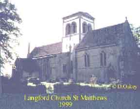
Sorry not much on the church at present, but hope to rectify this in the future
|